
How the Mojave Groundwater Bank’s Aquifer Recharges
The Mojave Groundwater Bank would capture fresh groundwater before salinity and evaporation, conserving water from an aquifer replenished by rain and snow.
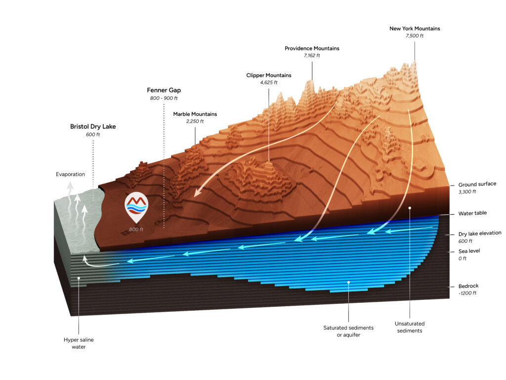
Rain and snow from mountains rising above 7,500 feet recharge the aquifer beneath the Mojave Groundwater Bank, located at the base of the Fenner, Bristol and Cadiz watersheds that together span more than 2,000 square miles. Groundwater moves slowly toward their natural outlet at the Bristol and Cadiz dry lakes. The project would manage groundwater levels at Fenner Gap, about 800 feet above sea level, to capture fresh water before it reaches the highly saline groundwater beneath the dry lakes and is lost to evaporation. Cadiz is developing the project in partnership with public agencies and Native American tribes. A County-approved management plan governs conservation and water supply through adaptive management.
Summary
- Rain and snow have replenished the Mojave Groundwater Bank’s aquifer for millennia. Groundwater continues to move through the watershed toward the dry lakes.
- Desert Research Institute evaporation measurements support the Mojave Groundwater Bank’s estimated long-term recharge of approximately 32,000 acre-feet annually.
- The Mojave Groundwater Bank would conserve stored fresh groundwater already moving toward the dry lakes and make it available for beneficial use.
- The Mojave Groundwater Bank’s management plan provides for an average annual supply of 50,000 acre-feet over 50 years, with monitoring and safeguards.
Rain and Snow Replenish the Aquifer
Snowmelt and rainwater begin their journey as far away as the New York Mountains, moving down through a network of high desert mountain ranges toward Fenner Gap. Rain and snow infiltrate fractured mountain bedrock, while temporary stream flows soak into sandy valley washes. Groundwater moves slowly through the aquifer, following the slope of the basin.
At the valley floor, water collects in a natural storage basin extending about 1,200 feet down to bedrock. As rain and snow continue to replenish it, groundwater flows onward toward the Bristol and Cadiz dry lakes, where it eventually evaporates.
This natural sequence has continued for millennia:
- Rain and snow supply the watershed: Precipitation falls across the mountains and valleys of the closed basin surrounding the project.
- Water infiltrates underground: Fractured bedrock and sandy washes provide pathways for water to move below the surface and replenish groundwater.
- Groundwater flows toward the dry lakes: The Bristol and Cadiz dry lakes are low points in the basin, receiving groundwater moving from higher elevations.
- Fresh groundwater becomes saline: Once water reaches the dry lakes, it becomes hypersaline and evaporates.
Groundwater beneath the dry lakes has salinity levels about ten times those of the Pacific Ocean. The proposed wellfield would capture fresh groundwater before that loss, including water already beyond the wellfield and moving toward the dry lakes.
Measured Evaporation Supports the Recharge Estimate
CH2M HILL, now Jacobs, used site-specific data and the U.S. Geological Survey’s INFIL3.0 model to estimate long-term average recharge of approximately 32,000 acre-feet annually. The County’s groundwater management plan reports the same estimate.
Desert Research Institute scientists measured evaporation at the Bristol and Cadiz dry lakes in 2011. CH2M HILL’s evaporation analysis used those measurements to estimate annual evaporation of 31,590 acre-feet. The Final EIR identifies the close agreement between the evaporation and recharge estimates as support for the recharge model. Aquilogic’s 2013 hydrology review also examined the evaporation findings.
Groundwater-flow modeling then evaluates how the aquifer responds to proposed withdrawals. The management plan identifies Geoscience Support Services’ use of MODFLOW2000 and MT3D for flow and transport analysis. Recharge estimates are inputs to that work, alongside information about the aquifer and proposed pumping.
The Technical Review Panel reviews monitoring data and recommends management actions to public agencies. San Bernardino County retains final oversight decisions.
Recharge and Stored Water Supply the Wellfield
Cadiz estimates that the wider aquifer system contains more than 30 million acre-feet of groundwater. The project’s planned water supply averages 50,000 acre-feet annually over 50 years, totaling 2.5 million acre-feet. Supply may reach 75,000 acre-feet in a single year, with lower volumes in other years to maintain the long-term average. The average annual supply is less than one-half of one percent of that estimated storage.
Managing groundwater levels would capture stored fresh water beyond the wellfield before it reaches the dry lakes. The Final EIR’s conservation analysis explains why pumping only at the natural recharge rate would leave that stored water moving toward salinity and evaporation. Conserving it is the purpose of the planned groundwater drawdown and allows the supply to exceed annual recharge.
Natural recharge continues to replenish the system, while monitoring tracks how withdrawals affect groundwater levels and other resources. The safe-yield plan sets supply parameters and adaptive management requirements for conserving water and protecting groundwater resources.
Pumping Limits and Monitoring Protect Groundwater
The County-approved management plan combines monitoring with corrective measures for groundwater levels, water quality, springs, subsidence, and air quality. San Bernardino County retains oversight, and corrective measures can include changing pumping locations, reducing extraction, or stopping pumping for a period necessary to correct predicted impacts.
The plan’s initial groundwater floor is an averaged management level within two miles of the wellfield, set 80 feet below baseline. It allows specified short-term incursions of up to three consecutive years, subject to a ten-year average at or above the floor and other conditions preventing undesirable results. After 15 years of operation, an application to lower the floor requires Technical Review Panel review and County approval based on the plan’s findings.
The floor measures a change in groundwater elevation, not the aquifer’s full depth. CH2M HILL’s groundwater assessment documents water-bearing fractured carbonate rock to about 1,000 feet below ground surface at the Fenner Gap test well TW-1. Water-bearing rock extends to about 1,000 feet below ground at TW-1.
Groundwater monitoring at Cadiz Ranch follows requirements established in the 1993 agricultural environmental review and a County-approved monitoring plan from 1997. The 2019–2023 monitoring report continues that long-term record of agricultural operations. It documents seasonal pumping and recovery, slight irrigation-well declines, and no evidence of subsidence relative to the 1997 baseline.
Natural Recharge Supports a Managed Groundwater Supply
The Mojave Groundwater Bank would conserve fresh groundwater already moving through the basin toward salinity and evaporation. Rain and snow have replenished this system for millennia. Desert Research Institute’s field measurements support an annual evaporation estimate close to the modeled recharge of approximately 32,000 acre-feet. Capturing stored water beyond the wellfield would make additional water available for beneficial use.
Cadiz estimates that the wider aquifer system holds more than 30 million acre-feet of groundwater. The project’s planned average annual supply of 50,000 acre-feet is less than one-half of one percent of that estimated storage. County oversight, monitoring, and adaptive management govern that supply and the protection of groundwater resources.
Frequently Asked Questions
How much water is stored in the aquifer system?
Cadiz estimates more than 30 million acre-feet of groundwater in the Mojave Groundwater Bank’s wider aquifer system. The project’s planned average annual supply of 50,000 acre-feet is less than one-half of one percent of that estimated storage.
How much water would the Mojave Groundwater Bank supply annually?
The project’s planned water supply averages 50,000 acre-feet annually over 50 years, totaling 2.5 million acre-feet. Supply may reach 75,000 acre-feet in a single year, with lower volumes in other years to maintain the long-term average. The management plan’s safeguards govern that supply.
How do evaporation measurements support the recharge estimate?
Desert Research Institute scientists measured evaporation at the Bristol and Cadiz dry lakes. CH2M HILL used those measurements to estimate annual evaporation of 31,590 acre-feet. The Final EIR identifies the close agreement with the modeled recharge estimate of approximately 32,000 acre-feet annually as supporting evidence. The annual totals are estimates informed by field measurements.
Why can planned pumping exceed the estimated recharge rate?
The project would capture stored fresh groundwater already moving beyond the wellfield toward the dry lakes. Managing groundwater levels allows that water to be saved before it becomes saline and evaporates. The Final EIR identifies conserving this water for beneficial use as the project’s fundamental purpose. The planned supply combines that conservation with natural recharge under the County-approved management plan.
Related Articles
The Mojave Groundwater Bank is designed to provide clean, reliable and affordable water to underserved communities in the Southwest. Take a closer look at the science, safeguards, and community partnerships behind the project.